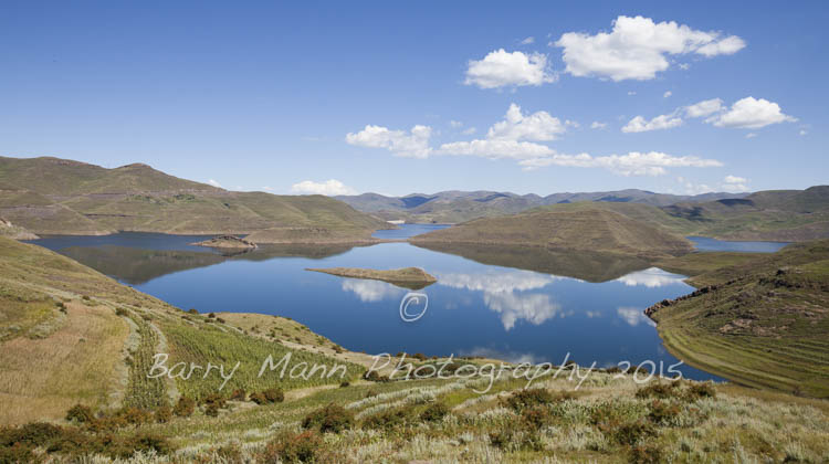

Mohale Reservoir, Lesotho
The drought in Lesotho has yet to really hit the headlines outside of the country, with many choosing to focus on the drought within many areas of its larger neighbour, South Africa.
Having lived here for over 3 years what I do know is that every year water has tended to be in short supply after the long dry winters (April to October) & seeing people line their buckets up by the pump or tap in the hope of getting water every 2nd or 3rd day seems normal in late October/early November. Usually the shortage lasts for a few weeks at most as the springs are replenished by the spring rains which start falling in mid-October. These are the same rains which allow farmers to plant their crops each year.
This year has been different though The spring rains have not arrived and the Basotho people & their animals are getting increasingly desperate for water, the water they need just to survive, let alone to be able to plant the staple crops they depend upon. Here in the Maphutseng Valley, near Mohale’s Hoek, we have only received around 27mm of rain since 1 October, 1/10th of the rainfall that we would usually expect. All around life is tough & each day without rain only exacerbates the problem. My previous post, highlights some of the problems people are having accessing water.
In light of this and the fact that Lesotho has been in the news recently, signing an agreement with South Africa & Botswana to supply water to Botswana, I decided to take a trip to see how one of the 2 big reservoirs in Lesotho, Mohale Reservoir, was doing after such a long period with such little rain.
At 145 m high, Mohale Dam is quite a feat of engineering, being the highest concrete-faced rock-filled dam in Africa, and is the 2nd of a series of dams & reservoirs of the Lesotho Highlands Water Project. Katse Dam was the first to be completed in 1997 & Mohale followed 5 years later in 2002. When full it should hold 950 million m³ of water, which is pumped through a 32km underground tunnel system to top up Katse Reservoir. The water from Katse is then pumped through another transfer tunnel to Muela Reservoir which ultimately supplies the water hungry industry in the Gauteng Region of South Africa.

Mohale Reservoir & Dam, Lesotho (March 2010)
The reservoir is currently far less than full. The latest figures I can find for the reservoir levels are from the Lesotho Highland Water Project figures for 31 October 2015, which show that it was only 39% full & I can only imagine that with the lack of rain over the past 2 months that those levels have dropped even further. How much lower the reservoir levels can fall remains to be seen but if the drought continues it will get closer to reaching its minimum operating height of 2005m above sea level. Lets hope that the rains that are forecast in March will be sufficient to return the reservoir levels to the levels needed to sustain the water supply to South Africa & the communities downstream through the usually dry Lesotho winter.
The images below shows Mohale Reservoir in March 2010 & in December 2015.

Mohale Reservoir, Lesotho (March 2010)

Mohale Reservoir, Lesotho (December 2015)

Road Bridge over Mohale Reservoir (March 2015)

The same road bridge in December 2015
One interesting consequence of the reservoir levels being much lower than normal is the re-appearence of some of the villages & river valleys that were flooded when the dam was constructed. One of the main settlements that was flooded was the village of Ha Seostsa, located on the banks of the Jorotane River. Villagers were resettled on higher ground by the government as part of the building of the dam & subsequent flooding of the area but now people are able to see where they used to live. The stone circles in the images are actually old traditional thatched rondavels which would have been occupied by generations of the same family for hundreds of years, whilst there are also signs of a few more modern block built e houses with their brightly painted walls. The bigger building which is usually under water is probably the old school or church.

The lost village of Ha Seotsa, abandoned has reappeared as water levels in Mohale Reservoir have dropped.

The lost village of Ha Seotsa, Mohale Reservoir, Lesotho

Buildings from the village of Ha Seotsa , Mohale Reservoir, Lesotho

The old village of Ha Seotsa , Mohale Reservoir, Lesotho
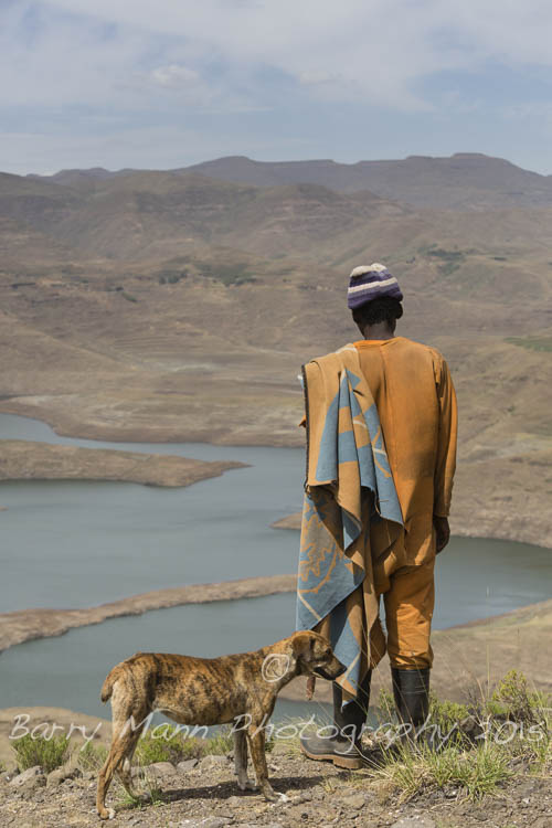
With the hill sides around Mohale looking dry & barren, stock owners & shepherds are making the most of the additional grazing land which has become available to them, as the reservoir levels have dropped. They will be hoping that the rains come soon to promote new growth but I suspect there will be many former residents looking down at their old fertile fields on the terraces next to the river, which used to provide them & their families with the crops that sustained them, reminiscing about what life used to be like in their old village community.

Cattle graze in the Jorotane River Valley in Lesotho (note the white ‘reservoir full’ level marker on the right of the image)

Shepherd looking down over the abandoned village of Ha Seotsa.
Barry Mann – December 2015